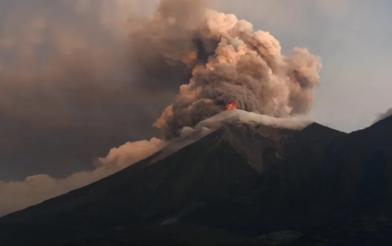
Guatemalan emergency authorities remained on high alert on Wednesday, 5 August 2026, as the Fuego volcano continued releasing ash, lava and dangerous volcanic material over nearby communities.
Approximately 1,700 residents had been moved into emergency shelters after evacuations began in villages located close to the volcano. Officials introduced red alerts in parts of Sacatepéquez, Escuintla and Chimaltenango, where around 29,000 people could be affected by the eruption.
Fuego entered a more intense period of activity earlier in the week, producing columns of gas and ash as lava and fast-moving pyroclastic flows travelled down its slopes.
Pyroclastic flows are extremely dangerous mixtures of superheated gas, ash and volcanic rock that can travel rapidly and destroy almost everything in their path. Authorities reported flows descending through several ravines surrounding the volcano.
Heavy rain created an additional danger by mixing with ash and loose volcanic material. This produced mudflows, known as lahars, which travelled as far as seven kilometres down some of the volcano’s drainage channels.
Officials said the mudflows had not reached villages or damaged buildings at the time of reporting. Nevertheless, expected rainfall could cause new or larger flows, particularly in valleys and river channels near the volcano.
Schools were closed in affected areas, while National Route 14—a major road connecting communities surrounding Fuego—was shut as a safety measure. Residents were instructed to avoid ravines and areas close to the volcano.
Guatemala’s national disaster-management agency, CONRED, advised people to wear face masks, protect water containers and follow evacuation orders. Ash can contaminate water supplies, damage crops and cause breathing problems, particularly among children, older people and individuals with respiratory conditions.
No deaths or serious injuries had been reported in the latest eruption as of 5 August. The evacuations were described as preventive measures designed to move residents before volcanic activity became more dangerous.
Fuego, whose Spanish name means “Volcano of Fire,” stands approximately 3,763 metres high and is one of Central America’s most active volcanoes. It is located around 50 kilometres southwest of Guatemala City.
The latest activity has revived painful memories of Fuego’s catastrophic 2018 eruption. That disaster killed more than 190 people, left hundreds missing and buried several communities beneath volcanic material.
Emergency teams are continuing to monitor seismic activity, ash emissions and conditions within the ravines. Further evacuations may be ordered if the eruption intensifies or heavy rainfall increases the danger of destructive mudflows.